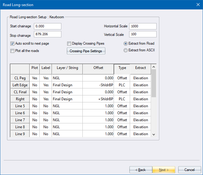
Road Long Section Setup
Long sections can be plotted from road data or from data in an ASCII file. Depending on where the data is extracted from, one of two options will be displayed.
From Road File
|
Option
|
Description |
||||||||||||||
|
Start chainage |
Enter the chainage from which long section extraction should take place. |
||||||||||||||
|
Stop chainage |
Enter the chainage at which long section extraction should terminate. |
||||||||||||||
|
Horizontal scale |
Enter the horizontal scale of the generated long section. |
||||||||||||||
|
Vertical scale |
Enter the vertical scale of the generated long section. |
||||||||||||||
|
Auto scroll to next page |
Select this checkbox to have multiple drawings generated if the long section cannot fit on a single page. |
||||||||||||||
|
Plot all the roads |
Select this checkbox to draw long sections for all the roads. The program will attempt to fit as many long sections onto each page. Plotting will start at Road 1, and stop when it encounters the first empty road. |
||||||||||||||
|
Display Crossing Pipes |
Select this checkbox to display the Crossing Pipes dialog and draw crossing Sewer, Storm or Stardust pipes on the road long section. |
||||||||||||||
|
Crossing Pipe Settings |
Click to display the Crossing Services and to specify which crossing services to display on the long section. |
||||||||||||||
|
Extract from Road |
Extract the data for the long section from a road design file. |
||||||||||||||
|
Extract from ASCII file |
Extract the data for the long section from a ASCII file. |
||||||||||||||
|
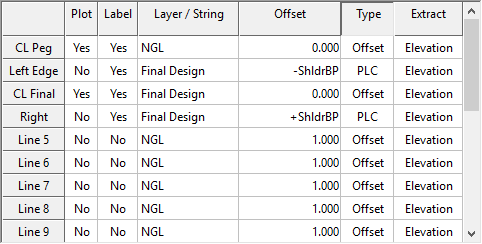
Data Table |
Up to 20 data items can be specified, where each data item represents either one of the long section lines, one of the long section labels, or both.
|
||||||||||||||
|
Back |
Click to return to the previous page. |
||||||||||||||
|
Next |
Click to accept the current entries and go to the next page. |
||||||||||||||
|
Cancel |
Click to cancel the function. |
From ASCII File
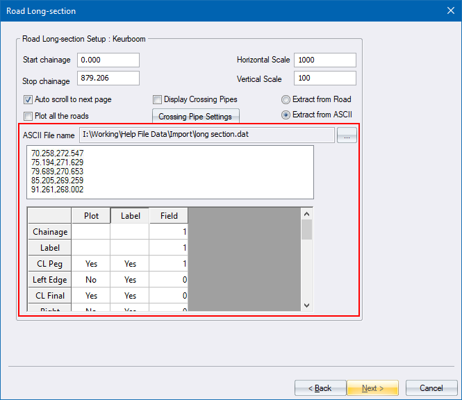
Up to 20 data items can be specified, where each data item represents either one of the long section lines, one of the long section labels, or both.
|
Option
|
Description |
|
ASCII file name |
Displays the name of the selected file. |
|
Browse Button (...) |
Click to select the name of the ASCII file, which must be comma-delimited, from which the long section should be extracted. |
|
Display list |
Displays the contents of the selected file. |
|
Chainage |
Specify the field that contains the chainage of the long section data item. |
|
Label |
Specify the field that contains the chainage label of the long section data item. This can be the same as that specified for the chainage. |
|
Plot |
Select whether this data item should be plotted. Right-click to toggle between Yes and No. |
|
Label |
Select whether this data item should be labelled. Right-click to toggle between Yes and No. |
|
Field |
Specify the field that contains the data that should be plotted and/or labelled. |